Friday, February 20, 2015

Climate change may dramatically reduce wheat production, study shows

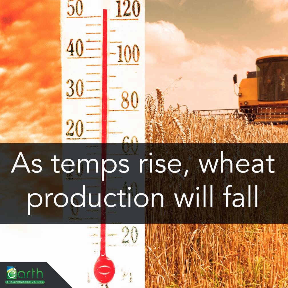
Vara Prasad, professor of crop ecophysiology and director of the USAID Feed the Future Sustainable Intensification Innovation Lab at Kansas State University, is part of a collaborative team that found wheat yields are projected to decrease by 6 percent for each degree Celsius the temperature rises if no measures to adapt to extreme weather fluctuations are taken.

Based on the 2012-2013 wheat harvest of 701 million tons worldwide, the resulting temperature increase would result in 42 million tons less produced wheat — or a loss of nearly one-quarter of the current wheat production.

“It’s pretty severe,” Prasad said. “The projected effect of climate change on wheat is more than what has been forecast. That’s challenging because the world will have to at least double our food supply in the next 30 years if we’re going to feed 9.6 billion people.”

Prasad and colleagues published their study, “Rising temperatures reduce global wheat production,” in a recent issue of the scientific journal Nature Climate Change. The study was supported through the Kansas Wheat Commission and the Kansas Wheat Alliance, two organizations seeking ways to increase wheat yield.

For the study, researchers systematically tested 30 wheat crop models against field experiments from around the world that were conducted in areas where the average temperature of the growing season ranged from 15 to 32 degrees Celsius. The models accounted for planting dates, planting rates, temperatures and other crop management factors.

With the models, researchers were able to look at the effects of temperature stresses on wheat and predict future changes based on temperature changes.

Researchers found that the effects from climate change and its increasing temperatures on wheat will be more severe than once projected and are happening sooner than expected. While Prasad said increases in the average temperature are problematic, a bigger challenge is the extreme temperatures that are resulting from climate change.

“Extreme temperature doesn’t only mean heat; it also means cold,” Prasad said. “Simply looking at the average temperature doesn’t really show us anything because it’s the extremities that are more detrimental to crops. Plants can handle gradual changes because they have time to adapt, but an extreme heat wave or cold snap can kill a plant because that adjustment period is often nonexistent.”

Researchers also found that increasing temperatures are shortening the time frame that wheat plants have to mature and produce full heads for harvest, resulting in less grain produced from each plant.

“It’s like having one minute to fill a tall glass with water. Under optimal conditions, we can fill that glass pretty well,” Prasad said. “But now we’re factoring in extreme temperatures that are affecting the growing window and the grain size. So it becomes like trying to fill that same glass, but now we only have 40 seconds to do it and the faucet is running slower.”

Currently, Prasad and colleagues at Kansas State University, in collaboration with the university’s Wheat Genetics Resource Center, are using growth chambers and heats tents to quantify the effects of temperature. The data will help in refining the crop models so that they can be more accurate in predicting wheat responses.

Their work will help scientists develop more robust models that can help farmers globally select more weather-tolerant and resilient wheat varieties based on their location. Additionally, farmers can determine the optimal planting date to avoid stress and minimize possible exposure to extreme weather events, such as heat and cold snaps, during the growing season. More


Tuesday, January 13, 2015

Global warming reduces wheat production markedly if no adaptation takes place

Future global wheat harvest is likely to be reduced by six per cent per each degree Celsius of local temperature increase if no adaptation takes place. Worldwide this would correspond to 42 million tons of yield reduction, which equals a quarter of current global wheat trade, experts warn.

Future global wheat harvest is likely to be reduced by six per cent per each degree Celsius of local temperature increase if no adaptation takes place. Worldwide this would correspond to 42 million tons of yield reduction, which equals a quarter of current global wheat trade.

Wheat plays an important role in feeding the world, but climate change threatens its future harvest. Without adaptation, global aggregate wheat production is projected to decline on average by six per cent for each additional degree Celsius temperature increase. Worldwide this would correspond to 42 million tons yield reduction for one 1°C global warming.

This result has been generated by an international research consortium to which Natural Resources Institute Finland (previously known as MTT Agrifood Research Finland) substantially contributed. The results were published online in the high impact journal Nature Climate Change.

Losses expected throughout the world

The researchers found out that in response to global temperature increases, grain yield declines are predicted for most regions in the world. Considering present global production of 701 million tons of wheat in 2012, this means a possible reduction of 42 million tons per one degree Celsius of temperature increase.

“To put this in perspective, the amount is equal to a quarter of global wheat trade, which reached 147 million tons in 2013. In addition, wheat yield declines due to climate change are likely to be larger than previously thought and should be expected earlier, starting even with small increases in temperature,” points out Prof. Dr. Reimund Rötter from Natural Resources Institute Finland.

“Therefore it is essential to understand how different climate factors interact and impact food production when reaching decisions on how to adapt to the effects of climate change.”

Increased variability weakens stability in grain supply

In the study, the researchers systematically tested 30 different wheat crop models against field experiments in which growing season mean temperatures ranged from 15 °C to 26 °C. The temperature impact on yield decline varied widely across field test conditions. In addition, year-to-year variability increased at some locations because of greater yield reductions in warmer years and lesser reductions in cooler years.

“Increased yield variability is critical economically as it could weaken regional and global stability in wheat grain supply and food security, amplifying market and price fluctuations, as experienced during recent years,” says Professor Rötter.

In its recent Assessement Report (AR5), the Intergovernmental Panel on Climate Change (IPCC) projects that global mean temperature may rise up to 5 °Celsius by the end of this century.

“Timely and adequate adaptation, such as cultivating more heat-tolerant wheat cultivars could substantially reduce climate change induced risks,” Rötter continues.

Unique and multi-locational study

Agrosystems modellers, Dr. Fulu Tao, Dr. Taru Palosuo and Prof. Dr. Reimund Rötter from Natural Resources Institute Finland participated to this collaborative research under the umbrella of AgMIP, The Agricultural Model Intercomparison and Improvement Project coordinated by Columbia University, NASA and University of Florida, USA. Apart from Finland, scientists from Germany, France, Denmark, Netherlands, Spain, UK, Columbia, Mexico, India, China, Australia, Canada and USA participated in this global study.

In a unique study set-up, the scientists first compared simulation results from a large ensemble of wheat crop growth models with experimental data, including artificial heating experiments and multi-locational field trials. They found that discrepancies between observation and simulation varied among individual models, whereby deviations increased with increasing growing season temperature.

Most reliable estimates of observed yields over the range of temperature regimes were achieved by using the multi-model ensemble median estimate. Based on these test results, scientists subsequently applied the multi-model ensemble to estimate wheat yields under increasing temperature in the main cultivation areas of the world. More


Thursday, January 1, 2015

Behind the veil of the Islamic State is a war for water

A little known fact of the war in Syria is that it started at the end of the worst drought in Syrian history, a biblical drought which forced over 1 million farmers into the cities.

Pulitzer Prize-winner Thomas L. Friedman interviewed Syrian refugees and farmers in Syria about the link between this drought and the start of the civil war. He comes to the conclusion that the drought certainly played some role and was probably a key tipping point for a bad situation to turn into a full scale war. In the documentary “Years of living dangerously” we see how wiki-leaked diplomatic cables and high level US officials such as Condoleezza Rice acknowledge this link.

But there’s a lot more happening to explain why behind the veil of a quest for an Islamic State (IS), there’s also a war for water in Syria and Iraq. Making the plight of citizens worse is the continued targeting of water supply networks by both regime and opposition forces, which have attacked strategic lifelines, such as water channels, to gain control of territory and to punish and put pressure on their opponents.

Opening the flood gates …

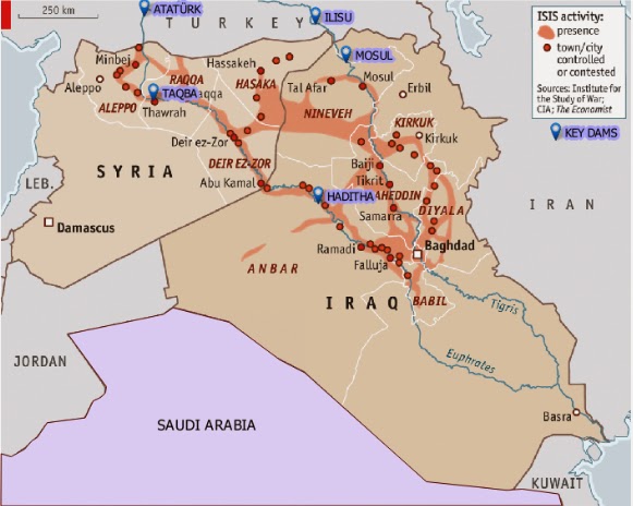
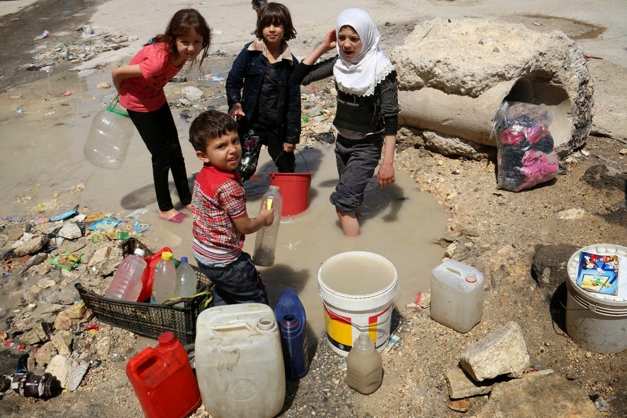
The Islamic State’s quest for hydrological control began in Syria, when it captured the Tabqa Dam in 2013. Rebel-held areas had been systematically denied electricity by President Bashar al-Assad’s forces in their effort to turn the population against the insurgency. The Tabqa Dam was built more than 40 years ago with Russian help and aimed to make Syria self-sufficient in energy production. Behind the dam is Lake Assad, which provides millions of Syrians with drinking water and is a vital irrigation source for farms. After the capture of the dam, IS opened the flood-gates to get maximum electricity supply for the areas they control and win favour with the local population. As a result, the lake dropped six metres, to a record low in May, which worsened the plight of millions of already destitute Syrians as severe water cuts began to hit Aleppo province.

Conflict over the water flowing though the Euphrates and Tigris is of course nothing new and predates religious wars. They were the first rivers to be used for large scale irrigation, in the region once known as the Fertile Crescent. Somewhere between 1720 and 1684 BC, a grandson of Hammurabi dammed the Tigris to prevent the retreat of rebels led by Iluma-Ilum, who declared the independence of Babylon. The Euphrates was already used as a weapon somewhere around 2500 BC, in another fight for Babylon, when the king of Umma cut the banks of irrigation canals alongside the Euphrates dug by his neighbor, the king of Girsu.

The Euphrates and Tigris are the two major and longest rivers in the Middle East. They both originate in Turkey. The Euphrates flows through Syria and Iraq to reach the Persian Gulf while the Tigris flows through Kurdish territory, meeting up with the Euphrates in the Southern Mesopotamian Marshes of Iraq. There are currently at least 46 dams in the Tigris-Euphrates basin, with at least 8 more planned or under construction. These dams have become key pieces of geo-political control in the region.

… and shutting down the flows

While one act of war is opening the flood gates, another is closing them. In 1974, Iraq threatened to bomb the same Tabqa Dam in Syria, alleging that the dam had reduced the flow of Euphrates River water to Iraq. But between then and now, Turkey, through its position upstream, has taken over as the most powerful regional commander of water, by completing the giant Ataturk Dam. In 1990 Syria and Iraq protested that Turkey now has a weapon of war: by closing the gates they could leave them dry. They had good reason to protest. In mid-1990 Turkish president Turgut Özal threatened to restrict water flow to Syria to force it to withdraw support for Kurdish rebels operating in southern Turkey.

In April 2014, the Islamic State blamed the low water levels in Lake Assad to Turkey’s closure of the Ataturk Dam. Sources found by Al Jazeera said that these claims are disputed. But even if the allegations are only partly true: they were used by the Islamic State to issue threats to ‘liberate Istanbul’, if that was necessary. So while Turkey, IS and Assad fight over water, millions of ordinary Syrians and Iraqi’s see their water levels drop dramatically. Not just by a new drought, with rainfall down by 50-85 percent since October 2013, but mostly due to a power struggle.

Tensions over water control in the region are set to heat up further if Turkey completes the Ilisu Dam on the Tigris River near the border of Syria. The Ilisu Dam will generate 1,200 MW and is part of the vast and ambitious Southeastern Anatolia Project, known as GAP after its Turkish title (Guneydogu Anadolu Projesi): a network comprising 22 dams and 19 power plants. The Ilisu reservoir will flood 52 villages and 15 towns, including Hasankeyf, a Kurdish town of 5,500 people, which is the only town in Anatolia that has survived since the Middle Ages and is under archaeological protection. It will displace approximately 16,000 people in the troubled Kurdish region.

The World Bank (WB), the British construction company Balfour Beatty and the Italian company Impreglio have all withdrawn from the problematic project. So have international funds and export credit from Austria, Germany and Switzerland. However, the project is currently funded by Turkish banks. Iraq and also Syria will be the most heavily impacted if the dam and others go through, with the most extreme projections holding that, owing to a combination of climate change and upstream dam activity, the Tigris and Euphrates rivers won’t have sufficient flow to reach the sea by as early as 2040.

If you live in Syria or Iraq and the water irrigating your field stops coming you might join the ranks of any army promising to attack those who kept the water for themselves – no matter if they tell you the truth or not. As is often the case in conflicts or epidemics it is not the facts themselves that count most but what people believe to be the facts. Those who can convince it’s the enemies fault that there’s not enough water will have the key to where the hearts and minds of the people will go to – no matter what the facts are.

The US finally finds a Weapon of Mass Destruction in Iraq

The Tabqa Dam is not the only dam attacked by IS. They are also trying to take the Haditha Dam, the second-largest in Iraq, raising the possibility of catastrophic damage and flooding. On Sunday, the US was bombing IS positions close to the dam. The IS militants are also fighting for control of the Euphrates River Dam, about 120 miles northwest of Baghdad and government forces were fighting to halt their advance. Insurgents from IS seized the Falluja Dam in Iraq in February and closed the floodgates to cause upstream flooding and to cut downstream water supply. Some 40.000 people were displaced just to flood the area around the city of Falluja to force government troops to retreat and lift a siege, while cutting water supplies and hydroelectricity generation for other parts of the country. All that was peanuts compared to what IS did next.

On August 7 IS captured the 1GW Mosul Dam on the Tigris – sending shock waves through Bagdad, Kuwait and the US. Whoever controls the Mosul Dam, the largest in Iraq, controls most of the country’s water and power resources. Located on the Tigris River upstream of Mosul, the dam, 3.6 km long and with 320 MW of capacity daily, formerly known as the Saddam dam, was built beginning in 1980 at a cost of 1.5$ billion USD, to bolster the regime during the Iran-Iraq war by a German-Italian consortium that was led by Hochtief Aktiengesellschaft. Its construction submerged many archaeological sites in the region yet more troubling is that because the dam was constructed on a foundation of soluble gypsum, it requires continuous grouting of the dam’s foundation to promote stability. Due to the engineering problems it presents it has been described recently by US engineers as “the most dangerous dam in the world.” And that was before the “most dangerous terror group ever” captured it.

A senior U.S. administration official said that “The failure of the Mosul Dam could threaten the lives of large numbers of civilians, threaten U.S. personnel and facilities – including the U.S. Embassy in Baghdad – and prevent the Iraqi government from providing critical services to the Iraqi populace,” (Source: Reuters). A 2006 U.S. Army Corps of Engineers report obtained by the Washington Post said the dam, which blocks the Tigris and holds 12 billion cubic meters of water, could flood two cities killing over a half a million people if it were destroyed or collapsed. The tsunami going to Mosul, a city of 1.7 million people, can be 20m high if the dam breaks with a full reservoir.

But even without a catastrophic failure, the dam is already at the epicenter of the war. Soon after the Islamic State captured the Mosul Dam they cut supplies to some villages in the north of the country that have not joined their cause. Recapturing this instrument of war was a sufficient reason for US forced to deploy air power to support Kurdish forces to recapture the dam. Saving the Yazidis from their mountain captured most media attention, but a key reason for the US to bomb Iraqi soil for the first time since 2011 was the fact that IS took the Mosul Dam. After bombing IS positions for several days, freshly re-equipped Kurdish fighters recently regained control of the dam.

Mega Dams & Water Management Practices

The importance of hydro-infrastructure in these battles and how it can be wielded firstly underlines the need for a serious re-appraisal of water management practices. Big dams (with funding from Multilateral agencies such as the WB, national and regional development banks, private equity and pension funds as well as from the Clean Development Mechanism, etc.) cause large scale displacement of populations, are ecologically destructive, wash away any other source of livelihood, and often saddle countries with debt while performing well below planned outputs as regards electricity generation. Moreover, compounded by climate change, contemporary ecological crises are leading to ever more conflict over trans-boundary water rights, such as for example between Ethiopia and Egypt, which are also on the verge of war over the construction of the Grand Renaissance and Gibe 3 dams, which would become Africa’s tallest. The world’s Big Dam Fan Club should take note of what has just happened in Syria and Iraq and realise that once disaster hits, hatred will not go to any God but to those who constructed the weapon of mass destruction. Water, rather than oil, is shaping up to be the key strategic resource in the region. More


Monday, December 29, 2014

Rising Temperature / Falling Grain Production

This one's for the "plants will grow better with more C02" crowd: A new study finds that wheat production will likely fall by 6% for every 1 °C increase in global temperatures. Wheat is one of the most important food crops in the world, and we'd be smart to keep it happy.

http://bit.ly/1JXcuj1


Thursday, November 20, 2014

Wells Dry, Fertile Plains Turn to Dust

HASKELL COUNTY, Kan. — Forty-nine years ago, Ashley Yost’s grandfather sank a well deep into a half-mile square of rich Kansas farmland. He struck an artery of water so prodigious that he could pump 1,600 gallons to the surface every minute.

Last year, Mr. Yost was coaxing just 300 gallons from the earth, and pumping up sand in order to do it. By harvest time, the grit had robbed him of $20,000 worth of pumps and any hope of returning to the bumper harvests of years past.

“That’s prime land,” he said not long ago, gesturing from his pickup at the stubby remains of last year’s crop. “I’ve raised 294 bushels of corn an acre there before, with water and the Lord’s help.” Now, he said, “it’s over.”

The land, known as Section 35, sits atop the High Plains Aquifer, a waterlogged jumble of sand, clay and gravel that begins beneath Wyoming and South Dakota and stretches clear to the Texas Panhandle. The aquifer’s northern reaches still hold enough water in many places to last hundreds of years. But as one heads south, it is increasingly tapped out, drained by ever more intensive farming and, lately, by drought.

Vast stretches of Texas farmland lying over the aquifer no longer support irrigation. In west-central Kansas, up to a fifth of the irrigated farmland along a 100-mile swath of the aquifer has already gone dry. In many other places, there no longer is enough water to supply farmers’ peak needs during Kansas’ scorching summers.

And when the groundwater runs out, it is gone for good. Refilling the aquifer would require hundreds, if not thousands, of years of rains.

This is in many ways a slow-motion crisis — decades in the making, imminent for some, years or decades away for others, hitting one farm but leaving an adjacent one untouched. But across the rolling plains and tarmac-flat farmland near the Kansas-Colorado border, the effects of depletion are evident everywhere. Highway bridges span arid stream beds. Most of the creeks and rivers that once veined the land have dried up as 60 years of pumping have pulled groundwater levels down by scores and even hundreds of feet.

On some farms, big center-pivot irrigators — the spindly rigs that create the emerald circles of cropland familiar to anyone flying over the region — now are watering only a half-circle. On others, they sit idle altogether.

Two years of extreme drought, during which farmers relied almost completely on groundwater, have brought the seriousness of the problem home. In 2011 and 2012, the Kansas Geological Survey reports, the average water level in the state’s portion of the aquifer dropped 4.25 feet — nearly a third of the total decline since 1996.

And that is merely the average. “I know my staff went out and re-measured a couple of wells because they couldn’t believe it,” said Lane Letourneau, a manager at the State Agriculture Department’s water resources division. “There was a 30-foot decline.”

Kansas agriculture will survive the slow draining of the aquifer — even now, less than a fifth of the state’s farmland is irrigated in any given year — but the economic impact nevertheless will be outsized. In the last federal agriculture census of Kansas, in 2007, an average acre of irrigated land produced nearly twice as many bushels of corn, two-thirds more soybeans and three-fifths more wheat than did dry land.

Farmers will take a hit as well. Raising crops without irrigation is far cheaper, but yields are far lower. Drought is a constant threat: the last two dry-land harvests were all but wiped out by poor rains.

In the end, most farmers will adapt to farming without water, said Bill Golden, an agriculture economist at Kansas State University. “The revenue losses are there,” he said. “But they’re not as tremendously significant as one might think.”

Some already are. A few miles west of Mr. Yost’s farm, Nathan Kells cut back on irrigation when his wells began faltering in the last decade, and shifted his focus to raising dairy heifers — 9,000 on that farm, and thousands more elsewhere. At about 12 gallons a day for a single cow, Mr. Kells can sustain his herd with less water than it takes to grow a single circle of corn.

“The water’s going to flow to where it’s most valuable, whether it be industry or cities or feed yards,” he said. “We said, ‘What’s the higher use of the water?’ and decided that it was the heifer operation.”

The problem, others say, is that when irrigation ends, so do the jobs and added income that sustain rural communities.

“Looking at areas of Texas where the groundwater has really dropped, those towns are just a shell of what they once were,” said Jim Butler, a hydrogeologist and senior scientist at the Kansas Geological Survey.

The villain in this story is in fact the farmers’ savior: the center-pivot irrigator, a quarter- or half-mile of pipe that traces a watery circle around a point in the middle of a field. The center pivots helped start a revolution that raised farming from hardscrabble work to a profitable business.

Since the pivots’ debut some six decades ago, the amount of irrigated cropland in Kansas has grown to nearly three million acres, from a mere 250,000 in 1950. But the pivot irrigators’ thirst for water — hundreds and sometimes thousands of gallons a minute — has sent much of the aquifer on a relentless decline. And while the big pivots have become much more efficient, a University of California study earlier this year concluded that Kansas farmers were using some of their water savings to expand irrigation or grow thirstier crops, not to reduce consumption.

A shift to growing corn, a much thirstier crop than most, has only worsened matters. Driven by demand, speculation and a government mandate to produce biofuels, the price of corn has tripled since 2002, and Kansas farmers have responded by increasing the acreage of irrigated cornfields by nearly a fifth.

At an average 14 inches per acre in a growing season, a corn crop soaks up groundwater like a sponge — in 2010, the State Agriculture Department said, enough to fill a space a mile square and nearly 2,100 feet high.

Sorghum, or milo, gets by on a third less water, Kansas State University researchers say — and it, too, is in demand by biofuel makers. As Kansas’ wells peter out, more farmers are switching to growing milo on dry land or with a comparative sprinkle of irrigation water.

But as long as there is enough water, most farmers will favor corn. “The issue that often drives this is economics,” said David W. Hyndman, who heads Michigan State University’s geological sciences department. “And as long as you’ve got corn that’s $7, then a lot of choices get made on that.”

Of the 800 acres that Ashley Yost farmed last year in Haskell County, about 70 percent was planted in corn, including roughly 125 acres in Section 35. Haskell County’s feedlots — the county is home to 415,000 head of cattle — and ethanol plants in nearby Liberal and Garden City have driven up the price of corn handsomely, he said.

But this year he will grow milo in that section, and hope that by ratcheting down the speed of his pump, he will draw less sand, even if that means less water, too. The economics of irrigation, he said, almost dictate it.

“You’ve got $20,000 of underground pipe,” he said. “You’ve got a $10,000 gas line. You’ve got a $10,000 irrigation motor. You’ve got an $89,000 pivot. And you’re going to let it sit there and rot?

“If you can pump 150 gallons, that’s 150 gallons Mother Nature is not giving us. And if you can keep a milo crop alive, you’re going to do it.”

Mr. Yost’s neighbors have met the prospect of dwindling water in starkly different ways. A brother is farming on pivot half-circles. A brother-in-law moved most of his operations to Iowa. Another farmer is suing his neighbors, accusing them of poaching water from his slice of the aquifer.

A fourth grows corn with an underground irrigation system that does not match the yields of water-wasting center-pivot rigs, but is far thriftier in terms of water use and operating costs.

For his part, Mr. Yost continues to pump. But he also allowed that the day may come when sustaining what is left of the aquifer is preferable to pumping as much as possible.

Sitting in his Ford pickup next to Section 35, he unfolded a sheet of white paper that tracked the decline of his grandfather’s well: from 1,600 gallons a minute in 1964, to 1,200 in 1975, to 750 in 1976.

When the well slumped to 500 gallons in 1991, the Yosts capped it and drilled another nearby. Its output sank, too, from 1,352 gallons to 300 today.

This year, Mr. Yost spent more than $15,000 to drill four test wells in Section 35. The best of them produced 195 gallons a minute — a warning, he said, that looking further for an isolated pocket of water would be costly and probably futile.

“We’re on the last kick,” he said. “The bulk water is gone.” More


Tuesday, November 18, 2014

Water Resource Management- New Publication 2014

Department of Organic Food Quality and Food Culture, University of Kassel and Department of Archaeology and Heritage Management, Rajarata University, Sri Lanka are pleased to announce about the publication of their new research paper, titled "Water Resource Management in Dry Zonal Paddy Cultivation in Mahaweli River Basin, Sri Lanka: An Analysis of Spatial and Temporal Climate Change Impacts and Traditional Knowledge" in the Special Issue "Changes in precipitation and impacts on regional water resources", Climate Journal International.

The paper may be accessed at http://www.mdpi.com/2225-1154/2/4/329

Abstract: Lack of attention to spatial and temporal cross-scale dynamics and effects could be understood as one of the lacunas in scholarship on river basin management. Within the water-climate-food-energy nexus, an integrated and inclusive approach that recognizes traditional knowledge about and experiences of climate change and water resource management can provide crucial assistance in confronting problems in megaprojects and multipurpose river basin management projects.

The Mahaweli Development Program (MDP), a megaproject and multipurpose river basin management project, is demonstrating substantial failures with regards to the spatial and temporal impacts of climate change and socioeconomic demands for water allocation and distribution for paddy cultivation in the dry zone area, which was one of the driving goals of the project at the initial stage. This interdisciplinary study explores how spatial and temporal climatic changes and uncertainty n weather conditions impact paddy cultivation in dry zonal areas with competing stakeholders' interest in the Mahaweli River Basin.

In the framework of embedded design in the mixed methods research approach, qualitative data is the primary source while quantitative analyses are used as supportive data. The key findings from the research analysis are as follows: close and in-depth consideration of spatial and temporal changes in climate systems and paddy farmers' socioeconomic demands altered by seasonal changes are important factors. These factors should be considered in the future modification of water allocation, application of distribution technologies, and decision-making with regards to water resource management in the dry zonal paddy cultivation of Sri Lanka. More


FAO ‘Pocketbook’ Highlights Environment, Food Security, Nutrition Links

17 November 2014: The world produces more food than it needs, leaving deep resource footprints in terms of carbon emissions, environmental degradation and land and water use, yet it is off track in achieving the World Food Summit (WFS) target of reducing the number of hungry people by 2015, according to ‘Food and Nutrition in Numbers.'

The publication from the Food and Agriculture Organization of the UN (FAO) provides a "pocketbook" compendium on the global state of nutrition.


FAO released the compendium in advance of the Second International Conference on Nutrition (ICN 2), which convenes on 19-21 November 2014, in Rome, Italy. The meeting is expected to adopt a declaration on nutrition and a framework of action on guidance for national policy commitments.


The pocketbook provides global, regional and national level data on the impacts of food systems, with the aim of highlighting the external aspects of nutrition. It addresses a range of topics on nutrition and health, including micronutrient deficiencies, obesity, non-communicable diseases (NCDs), food prices and trade. It also includes food security indicators and indicators on links between the environment, health and nutrition and data on agriculture-related carbon emissions and land use.


Data included in the publication provide "the starting point for evidence-based food policy analysis and for getting a more complete picture of health and environmental impacts associated with nutrition," emphasized Josef Schmidhuber, FAO's Statistics Division. Schmidhuber underscored "how much more food agriculture has produced over the past decades," but said that "what is equally remarkable is that in this world of plenty, we still have 800 million who don't consume enough calories and 2 billion who don't eat well."


FAO's Nutrition Division Director, Anna Lartey, highlighted the importance of nutrition in development, stressing that countries that do "not pay attention to the nutrition of its citizens will pay dearly in health costs and loss of productivity and this can significantly reduce its economic development." [UN Press Release] [UNRIC Press Release] [Publication: Food and Nutrition in Numbers] [IISD RS Coverage of ICN 2]

More


Saturday, November 8, 2014

Ocean acidification tops the annual list of important stories ignored by the mainstream media

Our oceans are acidifying — even if the nightly news hasn't told you yet.

As humanity continues to fill the atmosphere with harmful gases, the planet is becoming less hospitable to life as we know it. The vast oceans absorb much of the carbon dioxide we have produced, from the industrial revolution through the rise of global capitalism. Earth's self-sacrifice spared the atmosphere nearly 25 percent of humanity's CO2 emissions, slowing the onslaught of many severe weather consequences.

Although the news media have increasingly covered the climate weirding of global warming — hurricane superstorms, fierce tornado clusters, overwhelming snowstorms, and record-setting global high temperatures — our ocean's peril has largely stayed submerged below the biggest news stories.

The rising carbon dioxide in our oceans burns up and deforms the smallest, most abundant food at the bottom of the deep blue food chain. One vulnerable population is the tiny shelled swimmers known as the sea butterfly. In only a few short decades, the death and deformation of this fragile and translucent species could endanger predators all along the oceanic food web, scientists warn.

This "butterfly effect," once unleashed, potentially threatens fisheries that feed over 1 billion people worldwide.

Since ancient times, humans fished the oceans for food. Now, we're frying ocean life before we even catch it, starving future generations in the process. Largely left out of national news coverage, this dire report was brought to light by a handful of independent-minded journalists: Craig Welch from the Seattle Times, Julia Whitty of Mother Jones, and Eli Kintisch of ScienceNOW.

It is also the top story of Project Censored, an annual book and reporting project that features the year's most underreported news stories, striving to unmask censorship, self-censorship, and propaganda in corporate-controlled media outlets. The book is set for release in late October.

"Information is the currency of democracy," Ralph Nader, the prominent consumer advocate and many-time presidential candidate, wrote in his foreword to this year's Project Censored 2015. But with most mass media owned by narrow corporate interests, "the general public remains uninformed."

Whereas the mainstream media poke and peck at noteworthy events at single points in time, often devoid of historical context or analysis, Project Censored seeks to clarify understanding of real world issues and focus on what's important. Context is key, and many of its "top censored" stories highlight deeply entrenched policy issues that require more explanation than a simple sound bite can provide.

Campus and faculty from over two dozen colleges and universities join in this ongoing effort, headquartered at Sonoma State University. Some 260 students and 49 faculty vet thousands of news stories on select criteria: importance, timeliness, quality of sources, and the level of corporate news coverage.

The top 25 finalists are sent to Project Censored's panel of judges, who then rank the entries, with ocean acidification topping this year's list.

"There are outlets, regular daily papers, who are independent and they're out there," Andy Lee Roth, associate director of Project Censored, told us. Too many news outlets are beholden to corporate interests, but Welch of the Seattle Times bucked the trend, Roth said, by writing some of the deepest coverage yet on ocean acidification.

"There are reporters doing the highest quality of work, as evidenced by being included in our list," Roth said. "But the challenge is reaching as big an audience as [the story] should."

Indeed, though Welch's story was reported in the Seattle Times, a mid-sized daily newspaper, this warning is relevant to the entire world. To understand the impact of ocean acidification, Welch asks readers to "imagine every person on earth tossing a hunk of CO2 as heavy as a bowling ball into the sea. That's what we do to the oceans every day."

Computer modeler Isaac Kaplan, at the National Oceanic and Atmospheric Administration office in Seattle, told Welch that his early work predicts significant declines in sharks, skates and rays, some types of flounder and sole, and Pacific whiting, the most frequently caught commercial fish off the coast of Washington, Oregon, and California.

Acidification may also harm fisheries in the farthest corners of the earth: A study by the Arctic Monitoring and Assessment Programme outlines acidification's threat to the arctic food chain.

"Decreases in seawater pH of about 0.02 per decade have been observed since the late 1960s in the Iceland and Barents Seas," the study's authors wrote in the executive summary. And destroying fisheries means wiping out the livelihoods of the native peoples of the Antarctic.

Acidification can even rewire the brains of fish, Welch's story demonstrated. Studies found rising CO2 levels cause clown fish to gain athleticism, but have their sense of smell redirected. This transforms them into "dumb jocks," scientists said, swimming faster and more vigorously straight into the mouths of their predators.

These Frankenstein fish were found to be five times more likely to die in the natural world. What a fitting metaphor for humanity, as our outsized consumption propels us towards an equally dangerous fate.

"It's not as dramatic as say, an asteroid is hitting us from outer space," Roth said of this slowly unfolding disaster, which is likely why such a looming threat to our food chain escapes much mainstream news coverage.

Journalism tends to be more "action focused," Roth said, looking to define conflict in everything it sees. A recently top-featured story on CNN focused on President Barack Obama's "awkward coffee cup salute" to a Marine, which ranks only slightly below around-the-clock coverage of the president's ugly tan suit as a low point in mainstream media's focus on the trivial.

As Nader noted, "'important stories' are often viewed as dull by reporters and therefore unworthy of coverage." But mainstream media do cover some serious topics with weight, as it did in the wake of the police officer shooting of Michael Brown in Ferguson, Mo. So what's the deciding factor?

As Roth tells it, corporate news focuses on "drama, and the most dramatic action is of course violence."

But the changes caused by ocean acidification are gradual. Sea butterflies are among the most abundant creatures in our oceans, and are increasingly born with shells that look like cauliflower or sandpaper, making this and similar species more susceptible to infection and predators.

"Ocean acidification is changing the chemistry of the world's water faster than ever before, and faster than the world's leading scientists predicted," Welch said, but it's not getting the attention is deserves. "Combined nationwide spending on acidification research for eight federal agencies, including grants to university scientists by the National Science Foundation, totals about $30 million a year — less than the annual budget for the coastal Washington city of Hoquiam, population 10,000."

Our oceans may slowly cook our food chain into new forms with potentially catastrophic consequences. Certainly 20 years from now, when communities around the world lose their main source of sustenance, the news will catch on. But will the problem make the front page tomorrow, while there's still time to act?

Probably not, and that's why we have Project Censored and its annual list: More


Ground water depletion driving global conflicts - NASA scientist

ROME, Nov 7 (Thomson Reuters Foundation) - Global ground water supplies, crucial for sustaining agriculture, are being depleted at an alarming rate with dangerous security implications, a leading scientist said.

Cracked ground of the Atibainha dam Brazil

"It's a major cause for concern because most of the places where it (ground water depletion) is happening are major food producing regions," James Famiglietti, a University of California professor who conducts research for the National Aeronautics and Space Administration (NASA), said in an interview with the Thomson Reuters Foundation.

"India is the worst off, followed by the Middle East, and the U.S. is probably number three ... the Chinese, particularly on the north China plain, are more water limited than people believe."

Famiglietti's conclusions are based on his latest research paper "The global ground water crisis" published in the journal Nature Climate Change last month.

The study uses analysis of satellite images to warn that ground water in many of the world's largest aquifers is being exploited at a far faster rate than it can be naturally replenished.

Farming accounts for more than 80 percent of the United States' water use, according to the U.S. Department of Agriculture, and the figures are similar globally.

Famiglietti has been called to the Pentagon a number of times to discuss the potential impact of groundwater scarcity with leading military planners.

Water-related conflicts are already happening, he said, and security experts are bracing for more.

"In 90 percent of the world where there are violent conflicts, there are water scarcity issues," he said.

Water scarcity has been one component driving Syria's civil war, he said. The agricultural sector lacks sufficient water to farm, and a "young generation of unhappy farmers moved to the city and conflict ensued".

Oil-rich, water scarce countries in the Gulf currently rely on desalinated sea water for much of their water consumption.

Some analysts suggest that more countries will embrace energy-intensive desalination, particularly using nuclear technology, if current trends continue.

Famiglietti said this would not be a good option, as it requires too much energy, and won't be able to efficiently provide the volumes of water needed for large-scale agriculture.

Governments first need to acknowledge there is a problem, he said, and then factor scarcity into pricing, while investing in conservation and new technologies to promote efficiency. More


Thursday, November 6, 2014

AGWA Launches Toolkit for Climate Change Adaptation in Water Resources Management


4 September 2014: The Alliance for Global Water Adaptation (AGWA) and partners have launched a manual for dealing with uncertainty under climate change by applying climate-informed decision-making to water resource management, project design and risk evaluation.


The manual was launched in a seminar held during World Water Week, on 4 September.


‘Beyond Downscaling: A Bottom-Up Approach to Climate Adaptation for Water Resources Management' is the result of two years' work by AGWA, the World Bank, the Inter-American Development Bank (IDB), US Army Corps of Engineers, University of Massachusetts and RTI International, among others.


It provides practical guidelines for practitioners and project coordinators for risk-based decision making and adaptation of water systems by using a bottom-up approach. The book aims to “provide an alternative approach contributing to improvement in the quality and effectiveness of water resources management planning and project design under climate variability and change uncertainty.”


The manual covers: AGWA's approach to sustainable water management; climate change impacts on water resources; mainstreaming adaptation into water resources management; key tools for supporting climate risk assessment; and approaches to identifying adaptation strategies for water projects. It also makes the case for moving beyond down-scaling global climate models, to a bottom-up approach to climate adaptation in the water sector, and presents a framework for an AGWA-supported adaptation approach.


The approach supported by AGWA, inter alia: recognizes the need to integrate climate adaptation into existing decision-making processes; advocates for bottom-up approaches to vulnerability assessment; supports the use of “systematic decision trees based on existing water resources management approaches”; stresses the importance of creating flexible decision pathways; and emphasizes the integration of flexible governance mechanisms into water resources management.


Speaking at the launch, Marcus Wijnen, Senior Water Resources Management Specialist, World Bank, noted that the book is “work in progress,” and invited stakeholders to provide feedback. More


The 2014 World Water Week took place from 31 August-5 September, in Stockholm, Sweden. [AGWA Publication Webpage] [Publication: Beyond Downscaling: A Bottom-up Approach to Climate Adaptation for Water Resources Management] [Video of Launch]